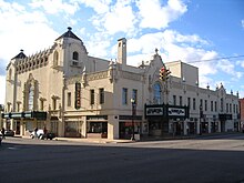
Miami is a city of 13,000 people (2020) in the Green Country region of Oklahoma on old US Route 66.
Understand
The town is named for the Miami Tribe of Oklahoma (the traditional name Myaamia, plural Myaamiaki, comes from an older native term meaning 'downstream people'). In a typical Oklahoman fashion, "Miami" is pronounced mia-muh by the locals. Miami is the capital of the Miami Tribe of Oklahoma, Modoc Tribe of Oklahoma, Ottawa Tribe of Oklahoma, Peoria Tribe of Indians, Seneca-Cayuga Tribe, and Shawnee Tribe; there are various native-owned businesses, including casinos, in the area.
Get in
By car, Miami may be reached by old US 66, US Route 69 or Interstate 44.
Get around
- Pelivan Transit, 333 Oak Street, Big Cabin, ☏ +1 918-783-5791, toll-free: +1-855-735-4826, fax: +1 918-783-5786. Rural bus transportation over a wide area from Tulsa northeast to the state boundary.
See

- 1 Coleman Theatre, 103 North Main St., ☏ +1 918-540-2425. Live theatre with elegant Louis XV interior, opened by George L. Coleman Sr. on April 18, 1929 and donated to the City of Miami in 1989. Tours available Tu-Sa.
- Dobson Museum, 110 A S.W., ☏ +1 918-542-5388. W F Su 1-4PM. Ottawa County Historical Society museums cover topics such as Oklahoma artist Charles Banks Wilson, the history of mining in Picher, Texaco marketing memorabilia, native artefacts (including a teepee), military veterans, Mickey Mantle and some of the early sports teams in the area. Miami Garden Club and historical society volunteers maintain the elaborate gardens.
- Miami Nine-Foot Section (Route 66 Ribbon Road), starts at E. 130th St. and South 550, rejoined US66 three miles later. A stretch of original Route 66 in use from 1921-1937 south of Miami is paved only nine feet wide. This segment predates US 66 itself (1926) as it was earlier part of an existing state highway.
Do
- Buffalo Run Casino, 1000 Buffalo Run (off Hwy 69A), ☏ +1 918-542-7140.
- Peoria Ridge Golf Course, 10275 South 600 Rd, ☏ +1 918-542-3805. 18 hole, par 72, slope 127, rating 74.1.
- The Stables Casino, 530 H St, ☏ +1 918-542-7884, toll-free: +1-877-774-7884. Always open.
- High Winds Casino, 61475 E. 100 Rd. Gaming, dining and sports bar.
Buy
Eat
- Waylan's Ku-Ku Burger, 915 N Main St, ☏ +1 918-542-1696. Popular Route 66 retro burger joint, the last location of what was a once-popular 200-store Midwest fast food chain in the 1960s. Food is made-to-order (owner Eugene Waylan usually mans the grill personally) and takes a bit longer to prepare than standard fast-food fare. Ask to hold the ice for fountain drinks, as there is a tendency to put too much ice in and a charge (about $0.27) for refills. under $10.
Drink
Sleep
- Buffalo Run Hotel, 1000 Buffalo Run Blvd, ☏ +1 918-542-7140, fax: +1 918-542-2908. Includes Internet, coffee maker, refrigerator and microwave, breakfast. Business facilities and ten-seat executive boardroom, exercise room, indoor pool. Adjacent to namesake casino and restaurants (Joe's Outback Casino, Coleman House Restaurant, Joe's Grill). $91-111.
- Days Inn by Wyndham Miami, 2120 East Steve Owens Blvd, ☏ +1 918-542-3382. Such a nice indoor pool area, with hot tub. Little waffle maker in the breakfast room.
- Microtel Inn & Suites, 2015 East Steve Owens Blvd, ☏ +1 918-540-3333. Indoor pool and hot tub here as well.
Nearby
Commerce

- Mickey Mantle Field, Commerce High School, 420 East D Street, Commerce OK. A nine-foot-tall, 900-pound statue on a 5-foot-tall pedestal commemorates local son and baseball legend Mickey Mantle.
Picher
| Note: Picher, 8 mi (13 km) north of Miami, is now a ghost town and part of the Tar Creek Superfund Site. Toxic heavy metal dust, especially lead, still contaminates the area. Do not touch, drink, or eat anything from the local waterways. Be wary of sinkholes caused by collapsing mine tunnels. | |
| (Information last updated 28 Jun 2023) |

Founded 1913 after lead and zinc deposits were discovered on leased Quapaw land, Pitcher was once a city of 15,000 (on US 69, bordering Treece, Kansas) which produced lead for bullets for two world wars. Mining ended in 1957; the population declined 80–90% in the following decade. 14,000 abandoned mine shafts, 70 million tons of mine tailings, and 36 million tons of mill sand and sludge were left behind, undermining 85% of the city's buildings and contaminating all of the surface and groundwater supplies with lead. A 2006 state-sponsored buyout and permanent evacuation were already well underway when, on May 10, 2008, an EF4 tornado killed eight people and cut a mile-wide swath through town. The tornado-damaged structures were never rebuilt.
The 1,000 maps, 500 photos and various artifacts from the Picher Mining Field Museum were moved to the Baxter Springs Historical Society Museum in 2008. The city hall was closed and its archives turned over to the Northeastern Oklahoma A&M College in Miami in 2010. Most buildings were torn down in 2011. The town disincorporated and disappeared from maps in 2013. In 2014, six residents remained. An arsonist burned the empty, abandoned mining museum to the ground on April 14, 2015.
While most buildings were demolished, a few still stand, mostly as ruins. An abandoned Catholic church, a ruined pool hall, an auction house, a building where mining equipment was sold and a small collection of homes are all slowly deteriorating.
Go next
| Routes through Miami |
| Tulsa ← Vinita ← | W |
→ Joplin → Springfield |
| Lawrence ← Ottawa ← W |
N |
→ Grove → Sallisaw |
| Tulsa ← Vinita ← | W |
→ Baxter Springs → Joplin |
| Kansas City ← Overland Park ← | N |
→ Vinita → Muskogee |
| Jct N |
W |
→ Wyandotte → Muskogee |


