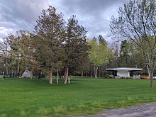
Londonderry is a large town in New Hampshire known for its apple orchards.
Get in
[edit]By car
[edit]Londonderry is accessible from exit's 4 and 5 on Interstate 93. State Route 102 is the only notable east to west route running from Route 101 near Epping to Route 111 in Hudson.
By bus
[edit]The Boston Express bus runs from stops at Exit 4 and Exit 5 in Londonderry to Boston's South Station and Logan International Airport.
By plane
[edit]
Substantial portions of the Manchester-Boston Regional Airport (MHT IATA) are in Londonderry, but there is no public transit from the airport to the rest of the town. Boston's Logan International Airport (BOS IATA) is less than an hour south by car in light traffic.
Get around
[edit]There is essentially no public transit within the town, and as destinations are spaced out, people almost always get around by driving.
See
[edit]


- 1 Londonderry Historical Society Museum, 140 Pillsbury Road, ☏ +1 603-432-2005, info@londonderryhistory.org. Open for special events and activities from May to October. Historical house museum that hosts tours.
- 2 Mack's Apples (Moose Hill Orchards), 230 Mammoth Rd, ☏ +1-603-432-3456. The oldest family-run farm in New Hampshire. Offers pick-your-own apples during harvesting season, ice cream, winter sledding/cross-country skiing, and other seasonal activities.
Do
[edit]Buy
[edit]- 1 Sunnycrest Farm, 59 High Range Rd, ☏ +1 603 432-9652. Local farm with pick-your-own, a store, and other seasonal activities.
Eat
[edit]- The Coach Stop, 176 Mammoth Rd, ☏ +1 603 437-2022. M-Sa 11:30AM-2PM & 4:30PM-close, Su 10AM-2PM & 4:30PM-close. Dinners $14-20.
- K's Italian Prosciutto's Pizza, 123 Nashua Rd, ☏ +1 603 425-7500, fax: +1 603-425-7506, info@prosciuttospizza.com. Su-W 11AM-9PM, Th-Sa 9AM-10PM. Dinners $8-11.
- [dead link] TJ's Bagel & Eatery, 123 Nashua Rd # 23, ☏ +1 603 425-1114, fax: +1 603-425-1118, vin@tjseatery.com. M-Sa 6AM-8PM, Su 6AM-2PM.
- Whippersnappers, 44B Nashua Rd (Apple Tree Mall), ☏ +1 603 434-2660, info@whippersnappersnh.com. Live entertainment several nights a week. Dinners $10-20.
Drink
[edit]- Two Cousins Sports Bar and Grille, 20 Rockingham Rd, ☏ +1 603 434-0166.
Sleep
[edit]- Sleep Inn, 72 Perkins Rd, ☏ +1 603 425-2110.
Go next
[edit]| Routes through Londonderry |
| Concord ← Manchester ← | N |
→ Salem → Boston |
| Wolfeboro ← Manchester ← | N |
→ Derry → Lawrence |

