The Pacific Coast Highway is one of America's most famous highways (probably second to Route 66). Stretching along the coast of California, the drive from San Diego to the Redwood National Forest in Northern California makes for a great trip.
Understand
It's one of California's slower state routes, closely following the coastline that is dominated in many places by cliffs and mountains. The alternatives, including US-101 and Interstate 5, are for those who want to travel more quickly, while CA-1 is the best route for sightseeing California's beautiful coast.

Prepare
- Driving - the most common way to travel this route. It was common 40 years ago to hitchhike the route, but not any more. Adventurous travelers could give it a shot and they would probably have more luck on the PCH than anywhere else in America.
- Motorcycling - Many motorcyclists consider the Pacific Coast Highway one of the most desirable rides in the Western United States. Plenty of twists, turns, and hills – along with gorgeous scenery – keep riders intent on the ride.
- Riding your bicycle is a great way to travel this route for experienced cyclists. Recommended direction is from north to south because of strong prevailing winds.
- Gas - Be aware that on the more rural segments of the road (particularly around Big Sur) there can be long stretches where gas stations are not plentiful, and prices are considerably higher than in other parts of the country with regular unleaded going for $1 - $1.50 more than the current prices elsewhere in the state.
Get in
Go

While California Highway 1 doesn't start until Dana Point in Orange County, it's worth your time to start at the southern end of the California coast in San Diego. San Diego offers many interesting attractions to the visitor in the neighborhoods away from the beach, such as Balboa Park, Downtown, and Old Town, but if you're just interested in seeing coastline then a worthy place to start is Cabrillo National Monument at the tip of Point Loma. There, you can get a gorgeous view of San Diego, the Bay, and the ocean, and learn about some of the history of the area. Also in the monument is a lovely tidepool area at the base of the ocean cliffs.
Heading north, you can drive along the beaches through the communities of Mission Beach, Pacific Beach, and La Jolla (La Jolla is also noted for its scenic sea cove), or just drive up I-5 and skip the beaches. You can continue through north San Diego County on I-5, although a far more scenic route runs along the coastal beaches; from I-5 after you pass La Jolla, head west on Genesee Avenue (exit 29) and continue straight as it turns into Torrey Pines Road (from La Jolla, just take Torrey Pines Road north). This will take you pass Torrey Pines State Park, between La Jolla and Del Mar, which makes for a scenic stop with cliffs overlooking the coast and trails leading down to the beach. Continuing north along the coast will take you through the lovely resort towns of Del Mar, Solana Beach, Encinitas, Carlsbad and Oceanside, where you'll drive along the scenic coast and over 5 natural lagoons connected to the ocean. On any given day you will see surfers and ocean goers enjoying the waves and ocean, each town has a distinctive Old California downtown area with an Amtrak/Coaster train station and a variety of places to eat and shop. Stop to watch the sunset and look for the green flash.
In Oceanside, you'll have to get on to I-5 to continue driving north. Just proceed on the Coast Highway through Oceanside until you get to the I-5 exit.
Orange and Los Angeles Counties

In San Clemente, you can get off I-5 at El Camino Real (exit 74), turn left, and drive by the Capistrano Beach until you get to California Highway 1 and the official Pacific Coast Highway. Head north on Highway 1 through Dana Point, Laguna Beach, Newport Beach and Huntington Beach; all four are scenic resort towns with great surfing beaches, and Huntington Beach is noted for its pier. Past Huntington is the smaller town of Seal Beach, which has a pier, popular beach and main street. Continuing north, you'll cross into Los Angeles County and enter Long Beach, where Highway 1 heads inland to cut through the South Bay region of Los Angeles County. However, you can make an easy detour to see the attractions of Long Beach, most notably the Aquarium of the Pacific and the Queen Mary ocean liner. The Pacific Coast Highway also skirts just north of Palos Verdes, with its ocean cliffs, tidepools, and scenic groves of eucalyptus trees. Hwy. 1 rejoins the coast near Redondo Beach and continues slightly inland through Hermosa Beach before becoming Sepulveda Boulevard and passing through Manhattan Beach, El Segundo, and directly under a runway at Los Angeles International Airport.
Be careful on the stretches of PCH that go through Manhattan Beach, Hermosa Beach and Redondo Beach -- there are many uncontrolled "zebra crossing" crosswalks that pedestrians can make use of -- at times, they have popped out onto the street with little warning. (Since around 2014-2015, the zebra crossings in Redondo Beach have been improved with pedestrian crossing lights.) The area is also notorious for pedestrians jaywalking across the highway to get to buildings on the other side of the street. So be sure to keep your eyes peeled and practice defensive driving techniques while on the PCH in the Beach Cities.
Furthermore, be aware that during times of moderate to heavy rain, the eastbound I-105 onramp just south of the Sepulveda Tunnel at Los Angeles International Airport floods, forcing drivers intending to use the freeway to suddenly merge back onto the PCH. This often causes long delays on the southbound lanes of PCH/Sepulveda from the Lincoln Boulevard-PCH/Sepulveda Boulevard fork until the southern end of the tunnel. Allow yourself at least a half a hour more time to get through the tunnel on rainy days.
After passing the airport, exit onto Lincoln Boulevard and follow Hwy. 1 back toward the coast through Westchester, Marina del Rey, Venice, and Santa Monica. Marina del Rey is noted for its huge yacht harbor, Venice for its colorful boardwalk and famed street performers and body builders, and Santa Monica for its pier and old-fashioned amusement park. Continuing north, Hwy. 1 hugs the coast on through Pacific Palisades, home to the J. Paul Getty Villa, and Malibu, with its famed mansions and beaches at the foot of the Santa Monica Mountains.

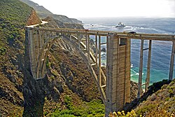
From Malibu, Hwy. 1 continues along the coast through Point Mugu State Park to Oxnard. Before reaching Oxnard, the road passes by Mugu Rock, formed by the cut the road made through the mountain. After Mugu Rock, the road travels inland through Oxnard north to US-101. Get onto US-101 and head west through Ventura, where it rejoins the coast. US-101 continues along the coast through Carpinteria, Montecito, Santa Barbara and Goleta. At the Gaviota State Park, US-101 breaks away from the coast and Hwy. 1 restarts, breaking away from US-101. Hwy. 1 heads north through Lompoc, Guadalupe, and Oceano before rejoining the coast at Grover Beach. At the northern end of Grover Beach, Hwy. 1 merges with US-101 again which proceeds through Pismo Beach before breaking away from the coast to head north to San Luis Obispo. There, Hwy. 1 splits off of US-101 again, traveling northwest to the coastal community of Morro Bay. Hwy. 1 continues along the coast through Cambria; San Simeon, home to the Hearst Castle; and along the very scenic cliffs of Big Sur. Several miles north of Big Sur, Hwy. 1 crosses over the beautiful Bixby Creek Bridge and the less famous but still beautiful Rocky Creek Bridge.
From there, Hwy. 1 continues through Carmel, then as a freeway past Monterey, Seaside, and Marina before becoming a two-lane road near Castroville, and then as a freeway again past Watsonville, Aptos, and Capitola to Santa Cruz. After Santa Cruz, the road becomes a rural road winding along the coast again to the San Francisco Peninsula.

Hwy. 1 continues as a rural road through several communities including Half Moon Bay and Moss Beach. As the highway approaches Pacifica, Highway 1 becomes a freeway segment through Daly City before breaking off as a city street, Junipero Serra Blvd, in San Francisco. Shortly after exiting off the freeway, Hwy. 1 becomes 19th Avenue through the Sunset district into Golden Gate Park. In the park, Hwy. 1 becomes Park Presidio Blvd through the Richmond district and into the Presidio park, where it merges with US-101 again. Shortly after exiting onto US-101, you'll drive over the world-famous Golden Gate Bridge over the San Francisco Bay into Marin County. US-101 continues past Sausalito and the Marin Headlands before Hwy. 1 splits off of US-101 again, heading west to the coast at Stinson Beach before running north along the coast through Bolinas, Point Reyes Station, and past the Point Reyes National Seashore.
Hwy. 1 continues along the coast, breaking off briefly to go through the town of Valley Ford before rejoining the coast at Bodega Bay. It heads north through Fort Ross, Sea Ranch, Gualala, Point Arena, Albion, Mendocino and Fort Bragg. After passing through the small town of Rockport, Hwy. 1 breaks away from the coast, finally ending at US-101 in the town of Leggett.
US-101 continues north through Garberville, Humboldt Redwoods State Park, Scotia, and Fortuna before rejoining the coast just before Eureka. US-101 continues along the coast through Arcata, McKinleyville and several small towns (including Trinidad) before finally reaching Redwood National Park, home to the world's tallest trees. US 101 continues along the coast through Klamath to Crescent City, the northernmost coastal town in California.
Stay safe
- Rock slides - The Malibu-Oxnard and Big Sur sections of the PCH are renowned for rock slides which can lead to delays when traveling
- Storms - California weather is famously pleasant but when it rains it pours. Large storms that come in off the Pacific are few and far between but when they come in it can make driving conditions precarious; keep abreast of the weather and remember that the road is safest and at its most scenic in sunny weather. PCH can be closed abruptly and can last up to a week or more if certain sections are impassable. Reopening depends largely on the damage and Caltrans efficiency to remove debris or rebuild certain sections. Be sure to know an alternate if this happens.
- Fog - The most likely hazardous condition, Route 1 can get fogged in, making driving conditions very hazardous, especially as drivers navigate around blind hairpin curves.
This road is quite isolated. Once south of Carmel there are no other highways connecting route 1 to the interior until you get to route 46, over 90 miles (145 km) away – other than the steep, narrow, winding, Nacimiento-Fergusson Road from the Salinas Valley. Be prepared to drive slowly for about two to three hours and have your wits about you. You will be driving along sharp hairpin curves atop very steep ledges and high cliffs. Certain sections of PCH do not have guard rails separating the road and the cliffs. You may notice other drivers, car or bus, making tight turns at 60 mph (100 km/h). They know the road, you don't.
Also, beware that there are very long stretches of the Central California coast with no cell phone or GPS reception whatsoever and few if any gas stations.
Go next
- Baja California (Mexico)
- Oregon and beyond
