


The United States of America is often called the land of the automobile. It has more than a quarter billion cars on the road (roughly 25% of all cars in the world), more than any other nation, as well as the highest number of cars per capita of any non-city-state country. Most Americans' primary form of identification is a driver's license. Consequently, car-dependent settlement patterns are more extreme and more the norm in the U.S. than anywhere else. Outside of certain cities, car ownership is widely assumed to be the default.
Still, many travelers want to get around without a car, whether for lack of a driver's license, to save money, or to minimize environmental footprint. Another reason is that city driving can be quite stressful and many people want to enjoy a relaxing holiday free from even the thought of their annoying daily commute.
Understand
[edit]| “ | Taken in the mass, the automobile is a noxious mechanism whose destiny in workaday urban use is to frustrate man and make dead certain that he approaches his daily occupation unhappy and inefficient. | ” |
—Neal Blaisdell, Mayor of Honolulu 1955-1969 | ||
American public transit authorities struggle to obtain enough funding for even the most basic maintenance. Heavy political lobbying from car manufacturers, airlines and oil companies also means that most taxpayer dollars earmarked for transportation are used to build more roads for more cars rather than rail or buses. Finally, most middle-class Americans live in suburbs deliberately designed to exclude public transit.
Taxicabs, and in the 21st century ride hailing services, are convenient for carless people in cities and suburbs, in particular for groups up to four people. They are controversial as they have kept demand of public transit down, and contribute more to traffic congestion than buses and bicycles.
If you decide to take the plunge, you'll often find low frequencies and decaying infrastructure built on decades-old technology, and you may also find that buses and trains are dirtier than in the rest of the developed world. Another problem of American public transit is the almost complete lack of fare integration – if you have to take a bus and a train or even two buses run by different operators, chances are you'll have to pay two different fares; there is rarely a ticket valid for all transfers. By and large buses don't give change, so hold on to one-dollar bills and quarters to pay for your ride. Many cities have introduced reloadable fare cards, which might give you a discount but above all make paying much smoother.
For both local and long-distance public transportation in the U.S., detailed information is almost always available online (on individual transit companies' websites and often on services like Google Maps), making it easy to plan ahead of time.
By train
[edit]- Main article: Rail travel in the United States

One popular alternative to car travel are the various forms of urban and intercity rail service. Unfortunately, due to successful political lobbying by car manufacturers and airlines, American rail services suffer from chronic under-investment and are slow, expensive, infrequent and often delayed, especially compared to their counterparts in Europe and East Asia, with intercity services that often run no more than once a day. However, urban rail networks are expanding in many cities and some intercity rail lines have had minor improvements as well.
Better served areas
[edit]The largest cities are often served by one or several urban rail and bus systems. In some cases, public transit is the best way for getting around a city. Some of them, like San Francisco's cable cars or Chicago's L, are city icons that double as attractions in their own right.
The area best covered by passenger rail services (of all kinds) is generally the Northeast between the cities of Boston and Washington, DC, with some urban rail and Amtrak services branching out further with reasonable travel times and frequencies beyond that area. In the Mid-Atlantic states and in New England, even some less populated communities have solid passenger railway connections.
Another area that is surprisingly well covered both in terms of frequency of trains and number of stops is California. Train service between the Bay Area and Los Angeles remains slow, with the planned high-speed rail line still many years from completion. However, the San Francisco Bay Area is well covered by BART (Bay Area Rapid Transit) and CalTrain, which goes all the way south to Gilroy. With the extension of the LA Subway and light rail lines (Metro Rail), meanwhile, the notoriously car-centric Los Angeles area is now very much visitable without a car. Current trends indicate that local and regional train coverage in California will only get better in the future, with several local and statewide rail improvements either scheduled for construction or being built right now.
Another city that is easy to get to by rail is Chicago, which has long been the main rail hub of the entire United States. Many Amtrak lines end in or pass through the city. If you are traveling by train from coast to coast, chances are you will pass through Chicago. However, few lines passing through there have top speeds much higher than 79 mph (127 km/h), even though some upgrades are planned or underway. Chicago also has a functioning and well-patronized commuter rail system that, in combination with Amtrak, offers good connections to some smaller cities in Illinois, Wisconsin, Indiana and Michigan.
Brightline is the first attempt to create a private passenger railroad in the US in the 21st century. As of 2023, it links Orlando to Miami with a top speed of 125 mph (200 km/h), with plans for an extension to Tampa in progress. Brightline is also building a railway line called Brightline West linking Southern California with Las Vegas, scheduled to open in 2028.
Particularly poorly served areas
[edit]Some of the most popular tourist destinations in the U.S. cannot be reached by train alone. Neither Las Vegas nor Yellowstone National Park get any regular train service. Amtrak serves 46 states: all but Hawaii (urban rail around Honolulu went operational in 2023), Alaska (served by the Alaska Railroad – see below), South Dakota and Wyoming, the latter two entirely without passenger trains.
Generally speaking, large parts of the American heartland, in particular the Great Plains and the Rocky Mountains, are poorly or not at all served by passenger railway. Even some relatively densely populated cities in the southeastern US and the Midwest are not well served by passenger rail. For example, Cincinnati has very few passenger trains arriving and they always arrive in the middle of the night.
Even in some of the states it does "serve," Amtrak does not serve the largest city or metro area. The one route that passes through Idaho, for example, cuts through the panhandle in the extreme north of the state, missing the major population centers. The same goes for Kentucky where none of the ten largest cities have any railway service.
Alaska is not served by Amtrak but does have train service through the Alaska Railroad, which mainly serves a corridor between Seward and Fairbanks via Anchorage. Outside of that corridor, Alaska is fairly inaccessible by rail. To be fair, however, much of Alaska is fairly inaccessible in general. For example, the capital, Juneau, can only be reached by sea or air. As a matter of fact, some of the places served by the Alaska Railroad are not connected to any road, making the train the only practicable way to get there.
Heritage railways exist throughout the U.S. In some places, they do provide some transportation value, with some serving a station Amtrak also serves and coordinating their schedule with Amtrak. In most places, however, they are tourist railways or dinner trains valued more for their novelty than for transportation beyond short round trips or circular tours.
If you want to combine bike and rail, Amtrak allows you to carry your bike if you reserve space ahead of time. See their regulations on special items for details. See also here.
By bus
[edit]
Intercity
[edit]- Main article: Intercity bus travel in the USA
While some places are served by Amtrak but not the main intercity bus companies, bus coverage is better overall than rail coverage. Some sort of intercity bus operates in all 50 states (whereas Amtrak only covers 46). Quality and price vary widely, but buses are generally less expensive than Amtrak (in the Northeast Corridor dramatically so) in exchange for a bit less legroom and less ability to walk or get food on the moving bus. Some bus companies are still or have historically been associated with immigrant communities (like the fabled Chinatown-buses or the newer Mexican-American buses) and are still mostly patronized by them. While intercity bus stops can be in all parts of town and they are often downtown as well, some are in somewhat problematic neighborhoods. Usually our city guides mention that and if that is the case, try to avoid late night arrivals or departures.
Local
[edit]While local bus coverage is by no means universal, most populated places in the U.S. have at least token bus service, with varying degrees of actual usefulness. Unfortunately, they are not always clearly labeled in system maps, unlike most urban rail systems. Getting around by bus in smaller cities often requires asking around or using one of the newer transportation apps. Night service, while slightly more common than it used to be, is still the exception rather than the rule, and even in major cities you may find yourself "stranded" at night. Buses in smaller cities often still require you to pay your fare to the driver using exact change. Many larger and more progressive cities have upgraded some bus lines to "proof of payment" systems or other forms of off-board fare collection, which require paying before boarding the bus and usually enable significantly faster trip times.
By plane
[edit]- See also: Flying in the United States, General aviation
Perhaps not very environmentally friendly, but flying is — at least for long distances — a fast and practical way from place to place. Even many smaller communities can be reached by plane. In most major US cities, there is a dedicated urban rail service or at least an express bus service connecting the airport to the city center. This is often even true for cities with otherwise virtually non-existent public transit.
By boat
[edit]The U.S. has a large system of inland waterways. Cruising the Erie Canal, the mighty Mississippi River or a myriad of other natural and man-made waterways is a great way to get around as well as an attraction in itself. In the nation's largest state, the Alaska Marine Highway System connects Bellingham (Washington) with communities along Alaska's southern coast, and many off-the-beaten-path Alaska communities can only be accessed by boat.
Around the country's coasts, ferries play a key role in reaching certain islands and peninsulas, ranging from New York's Staten Island to North Carolina's Outer Banks to San Francisco's Alcatraz. Sometimes the ferry is an alternative to cars or buses; in other cases it's the only way onto an island. Still, in many areas ferries have been largely supplanted by bridges and airports. Hawaii has only scant service: one connecting Maui and Molokai and the other serving Maui and Lana'i.
By bicycle
[edit]- Main article: Cycling in the United States
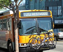
LA Metro bus with a bike rack in the front

Some U.S. cities have bike-sharing services. However, the presence of dedicated bike lanes is inconsistent between and even within cities. Good cities for cycling include Portland (Oregon), Chicago, Denver, Minneapolis/St. Paul, and a number of college towns.
Many areas have taken advantage of abandoned railroads to establish rail trails for walking and biking. The existing path of the train tracks can easily be converted into a paved trail that's nice and flat for a comfortable, smooth bike ride. Often scenic, they tend to be more for recreation than transportation, but some are practical ways to get from point A to B. A transcontinental bike trail called the Great American Rail Trail is being built from Washington, D.C. in the east to northwestern Washington State in the west. The organization coordinating its construction, the Rails-To-Trails Conservancy, claims that 50% of the trail (most of it not contiguous) is already complete, but this trail is not likely to be completed for many years.
In many cities, local buses have a bike rack on the front to allow you to combine bus and bicycle on the same trip. The bike rack is usually free to use (no extra fare).
On foot
[edit]Some American cities, mainly those which were already highly developed before the automobile became widespread, have downtown areas and some other neighborhoods that are good for walking. Among these are New York City, Washington, D.C., Philadelphia, Chicago, Boston, Baltimore, New Orleans, San Francisco, Seattle, Portland, and Denver.
For the truly dedicated, there are a number of (very) long distance hiking trails, such as the Appalachian Trail or the Continental Divide Trail. However, these trails include stretches where the next human settlement is several days' hike away. It's advised that you plan any trips along these trails (for which we have articles) very carefully.
Good cities
[edit]
- Austin - While it is served by Amtrak and the main intercity bus operators and has a very walkable and bike-friendly downtown core (if you can stand the heat), its public transport is only so-so.
- Baltimore - Built largely in the pre-car-era, Baltimore is rather walkable and accessible by public transit (especially around downtown and the Inner Harbor). In addition, the city runs a free bus service called the Charm City Circulator that stops by most areas of interest.
- Boston - Built largely in the pre-car-era and home to one of the U.S.'s largest student populations, Boston is rather walkable and accessible by public transit.
- Chicago - In addition to a highly dense urban core and good transit coverage, Chicago is also home to a major Amtrak hub, with trains leaving and arriving from all directions. Furthermore, getting around by bike is easier than in most other US cities.
- Cleveland - Surprisingly, this Midwestern city has a decent (by US standards) public transit network with a subway/light rail system, dubbed "The Rapid" by locals, that connects most points of interest, such as downtown, University Circle/Little Italy, and the airport. In addition, there are numerous bicycle trails and bicycle paths throughout the city.
- Denver - The Mile-High City has good sidewalks for pedestrians, a strong cycling culture, an excellent public bus system that runs late, a free shuttle bus on 16th St. in LoDo (Lower Downtown) and a sprawling light rail system that connects the downtown area to many suburbs and the airport. The Colorado Department of Transportation also runs the Bustang bus service from Union Station downtown to points throughout the state, from the western slope to the front range to the eastern plains and many popular mountain resorts.
- Honolulu - the urban core has many destinations close enough to walk -- it is less than 4 mi (6.4 km) from 'Iolani palace (downtown) to the far end of Waikiki -- and generally good sidewalks. Honolulu also has a good bus system that includes many outlying areas. A rail-based public transit system named Skyline is under construction; as of 2024 the first segments on the outskirts is complete and future segments scheduled for completion in 2025 and 2031 will bring the system to the airport and downtown.
- Minneapolis - Strong light rail, buses and bike lanes run throughout the city, making this one of the most accessible post-automobile cities in the nation to those without a car. The light rail system connects the airport and the downtowns of both Minneapolis and its twin, St. Paul. The downtown and uptown areas of both the Twin Cities are very walkable, too.
- New Orleans - The Big Easy has always been rather walkable, and its most notable sights are almost all downtown or close to it and thus still best reached on foot. New Orleans also has a large city bus network and is one of the only American cities whose streetcar service (partially) survived the heyday of the automobile. While generally too small and slow for residents, the streetcar network hits all the major tourist attractions and entertainment districts.

- New York City - There is hardly a place in New York that cannot be reached by foot, bus, subway, or ferry, and most residents, especially in Manhattan, choose to forgo a car.
- Philadelphia - Nearly all of the city of Philadelphia is accessible by some form of public transit (if not always especially frequent transit) and regional rail, trolley, and bus lines also serve some of Philadelphia's older (and more interesting) suburbs. After New Yorkers and perhaps Washingtonians, Philadelphians are the Americans most likely not to have a car or to use it only as a reserve vehicle rather than a primary means of getting around.
- Pittsburgh - A compact city with narrow streets and a significant student population, where nearly a quarter of households go without a car. Bus service is quite good, even into the evening, but rail service is limited to downtown, the stadium district, and a few suburbs. Bikeshare coverage is good, and most bikes have electric assist to tame the city's hilly geography.
- Portland (Oregon) - calls itself the bicycle capital of America and is rather well covered by public transport - both bus and light rail - as well.
- San Antonio - While most of the city is probably one of the worst offenders in terms of car dependent sprawl, the downtown area itself where most of the visitor attractions are located is very walkable. Renting a car, however is the best way to visit some of the theme parks and other outlying attractions since its public transport is only so-so.
- Salt Lake City - Believe it or not, this city is actually well served by light rail and a comprehensive bus system, which even reaches some of the nearby ski resorts.
- San Francisco - Whether it be the historic cable cars or the more modern modes of public transit, San Francisco has long been known as a city accessible without a car, which is aided by its demographics and the lifestyle choices of many of its inhabitants. The surrounding metro area (including San Jose, Oakland, and Berkeley) is connected by an overlapping set of public transit services, which are useful but tend get sparser and have lower frequency the farther you get from SF.
- Seattle - Another city in the U.S. that can be doable without a car, with frequent and often overlapping bus services from downtown to the adjacent neighborhoods. Even if you choose to stay near the airport (14 miles, or 23km, south of downtown) there is frequent light rail service from the airport into downtown that allows visitors to "commute" into downtown and its adjacent neighborhoods for a day/evening of sightseeing, shopping, dining, or bar hopping.
- St. Louis - The MetroLink light rail system runs to many of the metropolitan area's most popular destinations, such as downtown St. Louis, the airport, Delmar Loop, Grand Center Arts District, Forest Park, the Central West End, and Downtown Clayton, among other places.
- Washington, D.C. — The nation's capital boasts an extensive and well-functioning subway network. The capital itself is highly walkable and has a strong network of bike lanes. A large bike-share system makes getting around even easier.
Difficult cities
[edit]
- Albuquerque - The largest city in New Mexico, despite some strides in the development of its public transit system, is still primarily a driving city, so with the exception of Central Avenue public transit is still for the most part very underdeveloped.
- Atlanta - outside of a rather small downtown core, there is little public transportation in part due to the city's sprawling nature. Where MARTA's subway does go, it's hands down the easiest way around. If you have a longer layover at the world's busiest airport, popping out on MARTA to check out some sights is far more comfortable than being saddled with a car.
- Charlotte - Uptown is very dense, and almost all attractions in that part of town are easily reached by walking. However, only a few other districts (such as NoDa and Dilworth) are truly pedestrian-friendly and the rest of the city is rather unfriendly to pedestrians. That being said there is one light rail line in use.
- Dallas-Fort Worth Metroplex - The nation's sprawling fourth-largest urban area is hard to get around without a car, especially outside Dallas and Ft. Worth proper. Arlington, the largest of the suburbs separating the pair, is the largest city in the US without even a token city bus network. That said, the downtown areas of both Dallas and Fort Worth have direct rail links to DFW International Airport, and most major attractions in those two cities are accessible by rail or bus.
- Detroit - the capital of the automotive industry is very car-dependent, as you would expect. In a small section of the downtown core, the People Mover and the Q line can be used to quickly navigate the area on rail. However, the cycling community is on the rise, in part owing to the re-purposing of some of the extra space in the hugely overbuilt road network to accommodate cyclists.
- Houston - the infamously sprawling oil city nevertheless has light rail and bus systems. Visiting here without a car is doable if your visits are confined to Downtown, Midtown/Museum District, or the Medical Center area, which are connected by light rail, and there is an expanding number of bike paths in the city. Renting a car is still highly recommended, however.
- Las Vegas - Walking is a fairly good way of getting around the Strip, the main gambling and tourist area. A monorail also runs parallel to the Strip (despite being impractically located behind the casinos). Almost everywhere else in the city is accessible by bus, though some lines may run as infrequently as once an hour. There is no rail system connecting the suburban areas with Downtown Las Vegas. Las Vegas is one of the largest American cities with no railroad service - it was abandoned in 1997.
- Los Angeles - Though L.A. is a major example of sprawl, local bus services have been improving, and L.A. has built over 100 mi (160 km) of urban rail since 1990. Light rail is expanding and a good option for the places which it serves, but there are still many areas not served by it. Still, a visit to L.A. without a car is very much possible if your primary destinations are served by light rail or frequent buses which include Downtown, Mid-Wilshire, Exposition Park, Hollywood, Santa Monica, or Old Pasadena. Public transit is generally still slower than cars over long distances, but it does avoid wasting time looking for parking, and the light rail system largely escapes L.A.'s notorious traffic. The situation can be expected to markedly improve even further in the near future, as a 2016 referendum to further expand Metro Rail services through the coming two decades succeeded, adding local funding and certainty on top of existing ballot measures to fund transit. The city will also host the 2028 Summer Olympics, which will mean a big boost to the public transit system and the ambitious "28 by 28" program of 28 transportation projects - including highways, public transit and bike infrastructure - promises to accelerate construction or build new projects before the 2028 Olympics.
- Miami - While Miami does have an elevated metro line that connects downtown with the airport and frequent bus service in some areas like Miami Beach, it is still advisable for tourists to rent a car here as not all areas popular with tourists are reachable by transit plus South Florida is known for its car dependent sprawl.
- Nashville - Outside of downtown, Nashville is probably one of the worst offenders in terms of car dependent sprawl and isn't very walkable.
- Orlando - Outside of the Walt Disney World and Universal Orlando Resort complexes, public transit is severely lacking in the city, which is also not very walkable in most areas.
- Phoenix - the biggest city not served by Amtrak and probably one of the worst offenders in terms of car dependent sprawl. However, a light rail line does connect downtown Phoenix with the airport and Tempe.
- San Diego - The San Diego metropolitan area is large and sprawling. Car travel is the most efficient way of navigating the city and county even though a light rail network (named the "Trolley") connects Downtown to the Mexican border crossing and other points of interest.
- Tampa - The city of Tampa and the Tampa Bay metropolitan area as a whole is large and sprawling and public transit is very lacking there.
The suburban cities/municipalities surrounding the "Good Cities" (listed above) 10-60 miles (16-100 km) out of the downtown core of the "Good Cities" can rival the "Difficult Cities" as well. So if you're staying in the surrounding suburbs or exurbs it may be worthwhile to consider a car if possible. If you want to forego a car, try to avoid suburban and exurban areas, at least outside of the big Northeast cities (which often have extensive and relatively frequent suburban rail networks)
Other popular destinations
[edit]
Most World Heritage Sites in the USA are national parks or otherwise in rural areas, and only about half of them can be reached without driving. Some natural attractions within a few hours' drive of a major city can be accessed via organized tours. For instance, tours run from Las Vegas to many nearby national parks. On such tours, however, your schedule and destinations within the expansive parks will be set by the tour company. Many of the places they serve can feel polished and tame compared to the vast wilderness surrounding them.
Otherwise, your car-free options are your feet or a bike. If possible, consider taking a bus to the park entrance and hiking or biking around inside. However, you should not attempt this without planning your trip carefully and bringing extensive supplies. This should be considered as an experience in itself rather than a regular means of transportation.
- The Adirondack mountains are accessible via the (aptly named) Amtrak Adirondack, and some other points can be reached either by heritage railroads or buses. On the navigable bodies of water you can of course cruise in small craft, but other than that you would have to rely on sturdy boots and firm legs to get around.
- Cahokia Mounds State Historic Site is less than a mile from a local bus stop, served by buses between East St. Louis and Collinsville (Illinois).
- Denali National Park, in the Alaskan Interior, is surprisingly accessible without a car: the town of Denali, right next to the park, is served by passenger rail, and shuttle buses take visitors around the park.
- Disneyland is served by several local bus lines.
- Hawaii Volcanoes National Park is served by five buses a day from Hilo every day except Sundays.
- Glacier Bay National Park is entered from the adjacent town of Gustavus, which in turn has an airport and a harbor where ships (including ) on the Alaska Maritime Highway dock, both a little over a mile from Gustavus. Visitors usually get around the park on some kind of watercraft: kayak, cruise ship, tour vessel or rental boat.
- Glacier National Park is one of the easiest national parks to get to by train. Amtrak's Empire Builder directly serves the park via two stations (West Glacier and East Glacier) and travels right next to the park for some distance. The park also has some bus services for getting around inside.
- Grand Canyon Village is accessible by a shuttle service from Flagstaff's Amtrak station. Another option is taking the train to Williams and the Grand Canyon Railroad (a tourist railway) from there to the rim of the Canyon.
- Niagara Falls can easily be visited by train. Amtrak's Empire Service and Maple Leaf take you directly into the city of Niagara Falls. The falls are also served by local bus routes from downtown Buffalo's bus terminal and Buffalo Niagara International Airport.
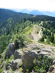
- Olympic National Park is another excellent place to visit without a car. As a matter of fact, it's one of the last roadless areas in the lower 48 states, and is as such a hiker's paradise. A sliver of the park reaches into the town of Port Angeles, about 5 miles (as the crow flies) north of the main portion of the park. Port Angeles has bus connections from Seattle, SeaTac Airport, and other towns in the region, as well as a ferry to the Canadian city of Victoria.
Hurricane Ridge Trail in the Olympic National Park - Redwood National Park can be reached by local bus lines operated by Redwood Coast Transit, connecting from nearby cities like Crescent City and Arcata. Both have a regional airport, and Arcata has a bus station served by both Greyhound and the Amtrak Thruway Motor Coach (connecting to trains in Martinez).
- Rocky Mountain National Park can be reached via a shuttle bus from Estes Park, which itself is about an hour Bustang bus ride from Denver.
- Many ski resorts are accessible without a car. Most commonly, ski resorts will provide their own private shuttle service. Some, such as Breckenridge, Aspen, or Vail, are accessible directly from the city. More uncommonly, some are accessible by public city bus, such as Eldora in Colorado or Mt. Hood in Oregon. The Winter Park resort, in Colorado, is accessible directly by seasonal train.
- Walt Disney World can be reached by public bus from Orlando and Kissimmee.
- West Yellowstone at the western entrance of Yellowstone National Park has an airport with flights during the summer months. During the summer there's also a bus service running in the park. There is no Amtrak service throughout the entire state of Wyoming.
- Yosemite National Park is accessible by buses meeting Amtrak's trains in Merced and Yarts Bus.
