Cleveland is a huge city with several district articles that contain information about specific sights, restaurants, and accommodation.
Cleveland is a culturally diverse city on the shores of Lake Erie, one of the Great Lakes, in Cuyahoga County, Ohio, USA. Recreational, cultural and educational opportunities are abundant throughout Northeast Ohio. You'll find world-class museums and cultural events, professional sports and amusement parks, and the most golf courses per capita in the United States. Places Rated Almanac ranks the area second in recreational options out of 354 US metro areas. This region ranks fifth in the nation in number of major cultural resources per one million residents.
The following are districts of the city of Cleveland. For the Cleveland Metropolitan area see Cuyahoga County.
Districts of Cleveland
Downtown The downtown district includes the area at the heart of the city around the mouth of the Cuyahoga River, including the Flats, Terminal Tower, the Warehouse District, Playhouse Square, the East 4th neighborhood, North Coast Harbor, and the sports arenas.
East Side The East Side is the portion of the city to the east of the river, including the city's world-class cultural and arts complex, and contains the following neighborhoods: University Circle, Buckeye-Shaker Square, Central, Collinwood, Corlett, Euclid-Green, Fairfax, Forest Hills, Glenville, Goodrich-Kirtland Park, Hough, Kinsman, Lee Harvard/Seville-Miles, Mount Pleasant, Nottingham, Slavic Village, St. Clair-Superior, Union-Miles Park, Little Italy, and Woodland Hills.
West Side The West Side is the portion of the city to the west of the river, including the West Side Market and the airport, and contains the following neighborhoods: Brooklyn Centre, Clark-Fulton, Detroit-Shoreway, Cudell, Edgewater, Ohio City, Old Brooklyn, Stockyards, Tremont, West Boulevard, and the four neighborhoods colloquially known as West Park: Kamm's Corners, Jefferson, Puritas-Longmead, and Hopkins.
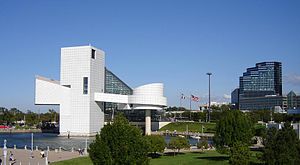
Cleveland from lakefront.Rock and Roll Hall of Fame and Museum
Cleveland is named after Moses Cleaveland, a veteran of the American War of Independence and distant relative of U.S. President Grover Cleveland, who surveyed the area and founded the city in 1796.
Cleveland is the urban center of Northeast Ohio, with 363,000 people in 2020. It is the center of the 15th largest combined metropolitan area in the United States. From 1890 until 1970, Cleveland was ranked as one of the 10 largest cities in the U.S. Like most U.S. cities, Cleveland began to lose population to suburban areas in the 1960s and 1970s. However, in the mid-1980s, Cleveland earned the nickname the "Comeback City" as the urban core experienced a dramatic revitalization process that continues today. As its "comeback" has continued, the official moniker is now the New American City as Cleveland has rightfully earned the reputation as a model of effective public-private partnership for urban planning.
Despite the common perception that Cleveland is an industrial town, just beyond the automotive and steel plants, a clean and beautiful downtown rises at the mouth of the Cuyahoga River on the southern shore of Lake Erie (often marveled over by visitors who are surprised you can't see the other side, i.e., Canada). Like other cities in the so-called "rust belt", Cleveland has endured growing pains as it makes its transition from a manufacturing-based economy. While Cleveland continues to play a leading role in building the U.S. industrial base, it has also developed economic prowess in the fields of health care, law, finance, insurance, real estate development, and professional services. In fact, Cleveland's economy frequently ranks amongst the most diverse and most dynamic in the USA.
Cleveland's long history of industrial wealth has left it chock full of cultural riches as well as the beginnings of a "sustainable city" movement. Serving as a global model for urban rebirth, Cleveland has been named one of the top 10 international visitor hotspots by Travel and Leisure magazine.
Cleveland experiences four seasons, with vibrant spring blossoms, hot humid summers, colorful autumns, and frigid winters.
July, on average, is the warmest month with a mean temperature of 71.9 °F (22.2 °C); however, Cleveland summers often experience temperatures in the high 80s to low 90s °F (low 30s °C) with relatively high humidity.
January, on average, is the coldest month with a mean temperature of 25.7 °F (−3.5 °C). Cleveland winters are cold, but the city usually experiences just a handful of heavy snowfalls, but does have the occasional windchill factor below 0 °F (-18 °C). Also, Cleveland gets lake effect snow from mid-November until the surface of Lake Erie freezes, typically by early February. This is snowfall due to Cleveland's position on the southern shore of Lake Erie, at the point where the shoreline shifts from an east-west direction to a northeast-southwest orientation. The East Side primarily experiences lake effect snow. Cleveland's snow belt, which receives substantially more snowfall than the West Side, begins on the East Side of the city (spreading southward from the Lake for up to 10mi (16km) in Greater Cleveland) and stretches northeast along the I-90 corridor past Buffalo as far as Syracuse.
Due to its proximity to Lake Erie, autumn in Cleveland has some enjoyable weather of the year. Some years, high 60°F (16°C) weather can be enjoyed through Halloween, without the humidity of the summer months.
Showplace of America: Cleveland's Euclid Avenue - once considered among the most beautiful and wealthy corridors in the world, read about the tightly knit community where Corporate America was born (including the likes of John D. Rockefeller).
The Encyclopedia of Cleveland History - the rich history of Cleveland includes the story of the industrial revolution, the roots of a vibrant arts and cultural mecca, and description of the proto-typical 'melting pot' of America. This is a thick book, but answers just about any question that arises - perhaps plan a stop at a Cleveland or Cuyahoga County Public Library.
41.411072-81.8383921Cleveland Hopkins International Airport(CLE IATA),☏ +1 216-265-6030.13mi (21km) southwest of Downtown. The RTA Red Line Rapid Transit provides frequent and fast rail service from the airport to downtown.$2.50.(updated Jul 2019)
41.511534-81.6899952Burke Lakefront Airport(BKL IATA),1501 N Marginal Rd.A small airport downtown right on the shore of Lake Erie that handles private jet, business, and general aviation traffic. Ultimate Air Shuttle offers twice daily flights to Cincinnati from Burke.(updated Jul 2019)
40.914933-81.4362293Akron-Canton Airport(CAKIATA).50mi (80km) south of Cleveland in Akron. Served by most major U.S. airlines.(updated Jul 2019)
Four two-digit interstate highways serve Cleveland:
Interstate 71 runs primarily west before heading due south into the suburbs, and most directly connects downtown to Cleveland Hopkins International Airport (via Ohio 237), the lower west suburbs (via I-480), the southwest suburbs, and eventually the state capital of Columbus. The curved section of I-71 that runs between W 25th Street and I-90/490 is referred to as the Metro Curve, due to its proximity to MetroHealth Medical Center.
Interstate 77, shown on maps as the Willow Freeway is Cleveland's oldest freeway, and heads due south from the Innerbelt along the east side of the Cuyahoga Valley and most directly connects downtown to the south suburbs, southeast suburbs (via I-480), Ohio Turnpike (I-80), and the city of Akron. The stack interchange at I-480 is sometimes referred to as The Cloverleaf, although the actual cloverleaf is located at the junction of Brecksville Road and Granger Road, which is just west of the later extension of the Willow Freeway.
Interstate 80/Ohio Turnpike is a toll road that connects the Greater Cleveland with Toledo to the west, and Youngstown and Pittsburgh to the east. Access to the city and its suburbs is from I-90, I-480 Eastbound, I-71, I-77, Ohio 8, and I-480 Westbound.
Interstate 90 connects the two sides (the terms "East Side" and "West Side" have deep root in defining this region) of Cleveland, and is the northern terminus for I-71 and I-77. I-90 separates from the Ohio Turnpike just west of Elyria and joins with Ohio 2 until Ohio 2 separates at Detroit Road in the west side suburb of Rocky River. I-90 then proceeds to I-71, I-490, and the Jennings Freeway (Ohio 176) in the Tremont neighborhood, and over the Innerbelt Bridge into downtown; from this confluence of freeways, I-90 is known as The Innerbelt, until it again merges with Ohio 2 at Dead Man's Curve and becomes the East Shoreway. I-90 once and for all splits from Ohio 2 near the Cuyahoga-Lake County line at the Euclid Spur, which connects to the northern terminus of I-271 and then parallels the lakeshore to Erie, PA.
Several other freeways also serve the city:
The Shoreway
Interstate 271 runs primarily north and south through the city's east suburbs, forming The Outerbelt East, which connects to I-90 at the end of the Euclid Spur in Lake County and I-71 just north of Medina. I-480 briefly follows I-271, and Ohio 8 connects I-271 to Akron in the south.
Interstate 480 runs east-west along the southern edge of the City of Cleveland, forming The Outerbelt South. It is a loop route into the city that both begins and ends at the Ohio Turnpike (I-80). I-480 is also the primary route to access Hopkins Airport from the east suburbs.
Interstate 490 connects I-71, I-90, and the Jennings Freeway (Ohio 176) on the near west side to I-77 on the near east side just south far enough to bypass much of downtown traffic.
The West Shoreway, which is also Ohio 2, follows the lakeshore across downtown west from I-90 past the Rock and Roll Hall of Fame and Edgewater Park to just short of the west side suburb of Lakewood.
The Jennings Freeway (part of Ohio 176) connects I-90/490 to I-480 on the west side of the Cuyahoga Valley. It serves as an effective alternate route to I-71 and I-77 from I-480 to downtown.
The Berea Freeway (part of Ohio 237) connects I-71 and I-480 to Cleveland Hopkins International Airport and the southwest suburb of Berea.
Ohio 2 connects far east lakeshore suburbs in Lake County to I-90 and I-271 (via the Euclid Spur).
Ohio 10/US 20 connects Oberlin in southern Lorain County to I-480 at its western terminus at the Ohio Turnpike.
US 422 becomes a freeway at I-271/I-480 and connects to the far southeast suburbs and Warren farther to the east.
41.5057-81.69655Cleveland Lakefront Station,200 Cleveland Memorial Shoreway.Ticketing and station hours: 9:30PM-1PM daily. The station is closed 1PM-9:30PM.The station is located on the north end of downtown (near FirstEnergy Stadium).(updated Oct 2019)
41.503402-81.682247Go Bus(Operated by Barons Bus),Greyhound bus station at 1465 Chester Ave(Additional stop at the airport.),toll-free: +1-888-95-GOBUS (46287).Travels to Parkersburg through Parma, Broadway Heights, Ankron, Canton, Mt Eaton, New Philadelphia, Newcomerstown, Cambridge, Caldwell and Marietta.
41.503402-81.6822438Greyhound,(bus station) 1465 Chester Ave(between E 13th and E 17th Sts),☏ +1 216 781-0520.Station and ticketing hours: 24 hours daily.Greyhound offers passenger bus service from many U.S. cities. Buses arrive and depart from Greyhound's Art Deco station in downtown Cleveland.
41.499924-81.6749359Megabus,E 22nd St and Prospect Ave(Stephanie Tubbs Jones Transit Center).Low-cost bus company offering service to Cleveland from Chicago and Toledo(updated Jan 2017)
Many boaters use the Great Lakes, St. Lawrence Seaway and their connection points as a travel route. There are many marinas and public boat ramps available for this purpose. Also, some commercial cruise lines provide Great Lakes cruises that include Cleveland on the itinerary.
Cleveland might be one of the easiest cities in the world to navigate. There are almost no one-way streets, because the city was planned to have "European Avenues" (which resulted in the foresight to make them broad enough for vehicular transportation that couldn't have been imagined in the late 1700s). Traffic is generally not a problem relative to other major U.S. metro areas. Throughout the downtown area, purple signs direct visitors to let you know where you are and what district you are in. The streets that run north-south are numbered, except for Ontario Street (the north-south street bisecting Public Square). Numbered streets are named "West", west of Ontario and "East", east of Ontario. (Broadview Road becomes the primary geographic boundary between 'East' and 'West' addresses to the south of the city.) The major east-west streets are generally named as "avenues".
Finding an address is simple as well. Numbers on north-south streets increase as you head south from Lake Erie, numbers on east-west streets increase as you head away from downtown and coincide with the numbered streets (i.e. 6500 Detroit Ave is located at the corner of Detroit Ave and W 65th St). Odd addresses on north-south streets are for buildings on the east side of the street, and even addresses are on the west side; on the west side of Cleveland, odd addresses on east-west streets are located on the south side of the street, while even addresses are on the north side—the reverse is true for east-west streets on the east side of Cleveland. This addressing scheme continues into most of the suburbs (some exceptions include Berea and Bedford) and even most cities and townships in Lake and Lorain Counties.
Most of the city is laid out in grids and has very clear signage enabling you to easily know where you are. Throughout the area, signs are thoroughly placed to indicate the route to the nearest major freeway, making the city extremely visitor-friendly!
Cleveland rush hours (7AM-9AM; 4PM-6:30PM in the afternoon) are light compared to many metropolitan areas, with traffic still moving near posted speed limits throughout most of the area. Some places notorious for slow or stop and go traffic are:
Morning:
I-71 Northbound from W 25th St into Downtown and from Bagley Rd to I-480
I-77 Northbound from I-490 into Downtown and from the Ohio Turnpike to I-480
I-90 Eastbound from W 25th St into Downtown
I-90 Westbound from E 55th St into Downtown
I-271 Northbound approaching I-480
I-480 Eastbound from the Jennings Freeway (Ohio 176) to I-77 and approaching I-271
Jennings Freeway (Ohio 176) approaching I-90/490
Afternoon:
I-71 Southbound from I-480/Ohio 237 to Bagley Rd
I-77 Southbound from downtown to I-490 and from I-480 to Pleasant Valley Rd
I-90 Westbound from downtown to the Innerbelt Bridge
I-90 Eastbound from downtown to Dead Man's Curve
I-271 Southbound approaching I-480
I-480 Westbound from W 130th St to I-71/Ohio 237
Road construction can impact travel times at rush hours, and usually occurs only from March to November. Any point in Cuyahoga County is normally reachable from any other point in the county by car in 45 minutes or less at non-peak driving hours.
Greater Cleveland is also served by a public bus and rail transit system, operated by the Greater Cleveland Regional Transit Authority, also known as "RTA". The rail portion is officially called the Cleveland Rapid Transit, but is known by locals as "The Rapid". It consists of two light rail lines, known as the Green and Blue Lines (which extend to the east side suburbs), and a heavy rail line, the Red Line (which connects Cleveland Hopkins International Airport and the west side suburbs with Tower City Center downtown and continues past University Circle to the inner-ring suburb of East Cleveland.) RTA's Waterfront Line is a short track specifically catering to tourists by connecting Tower City Center to the Flats Entertainment District, Cleveland Browns Stadium, Great Lakes Science Center, the Rock and Roll Hall of Fame and Burke Lakefront Airport.
A bus rapid transit line, called the "Health Line", runs along Euclid Avenue, providing a direct route between Cleveland's primary tourist attractions from downtown to University Circle. A $5 All-Day Pass is good for unlimited rides on the trains and the buses.
Greater Cleveland is expanding its bicycle trails and bicycle paths throughout the city. In addition, the city has numerous bicycle shops, mostly located on the near west side
Most attractions in Cleveland are Downtown. These include the Cleveland Museum of Art, Cleveland Museum of Natural History, and the Cleveland Botanical Gardens, all in and around the University Circle neighborhood. The Rock and Roll Hall of Fame & Museum, Great Lakes Science Center, and the Steamship William G. Mather Maritime Museum, are all on the lakefront.
Churches: Particularly visit the Tremont district in West Side (where the movie The Deer Hunter was filmed) and the Church Square district along Euclid Avenue between Downtown and University Circle (where you can see a broad sampling of houses of prayer, many of which are used by their second or third generations of faith). There are also several monumental churches in near east side suburbs of Cleveland Heights and Shaker Heights along Cedar Road, Fairmount and Shaker Boulevards.
Enjoy a game with the world's best sports fans. Cleveland is home to the second longest span of sold out baseball games (5 consecutive seasons in the late 1990s), the largest American League baseball attendance (72,086 on 8/9/1981) and the birthplace of Monday Night Football (9/21/1970). But given its storied sports past coupled with its weathered but dedicated fan base (ESPN named Cleveland the "Most Tortured Sports City"), terms like The Drive, The Fumble, The Shot, The Move, The Decision, 2 More Outs will ring in the ears of Cleveland sports fans for generations to come. After the Cavaliers finally ended the city's half-century long championship drought in 2016, The Block will also ring in fans' ears, but with a far happier note. Win or lose, Clevelanders (obviously) just love sports.
Progressive Field - Home of the Cleveland Guardians
Cleveland Harbor/Rock & Roll Hall of FameNo "mistake" about it! - Lake Erie. The shallowest and warmest Great Lake (with the most vibrant fishery) defines Cleveland's northern border and provides many opportunities for boating, fishing, swimming and walks. Cleveland boasts more miles of shoreline than any other city in the world, providing enjoyment from before Memorial Day to past Labor Day for boaters, fishermen and beach bums. Sailers, boaters, waverunners and jet skiers enjoy the lake with marinas, piers and boat launches available all along America's North Coast. Fishing is popular more than three seasons of the year with healthy populations of Walleye and Perch in Lake Erie. In the late fall and early winter, anglers pursue steelhead trout in the many rivers feeding Lake Erie up through Northeast Ohio and into Pennsylvania and Western New York.
Historically nicknamed the "Forest City" (due to a famous description of a highly sophisticated society amid a heavily forested environment in Alexis DeTocqueville's "Democracy in America" (1831)), Cleveland is a great place for outdoor activities. USA Today ranked Cleveland among the 10 best big cities for hiking. If you think Cleveland is just a "rust belt" city, get out to the nearest Cleveland Metropark. The parks form an Emerald Necklace around the Cleveland metropolitan area, so no matter which direction you go from downtown, you're headed toward a park. Biking, horseback riding, jogging and rollerblading are easily accommodated by the miles of trails (paved and unpaved) encircling Cuyahoga County. In the winter, visitors can cross country ski these same trails. Sitting upon the foothills of the Allegheny Mountains, Cleveland also provides downhill skiers with slopes throughout the area.
The Cuyahoga River winds through the city to feed Lake Erie. This once highly polluted river inspired the American environmental movement, and its restoration is a symbol of the city's recovery.
A river winds through it. Boaters, rowing crews, canoers and kayakers enjoy the diverse scenery along the Cuyahoga (a Mohawk Native American term, meaning "Crooked River"). The Cuyahoga provides a mosaic of the nightspots of the Flats (dockage available at restaurants and bars), downtown's towers rising up the hill, active industrial remnants of the birthplace of the petroleum and steel industries, pastoral settings and the Ohio and Erie Canal (which in the 1800s provided the connection between the Great Lakes and the Ohio River, ultimately enabling shipping from the Atlantic Ocean (via the St. Lawrence Seaway and the East Coast) to the Gulf of Mexico (via the Ohio and Mississippi Rivers)). The Ohio & Erie Canal has been preserved as a core element of Cuyahoga Valley National Park. In Ohio's only National Park, walk or bike the Canal Towpath. The National Park starts 8 miles south of downtown and stretches for miles down to Akron. The Towpath extends from Lake Erie in Downtown Cleveland through the southern suburbs past Akron, Canton, New Philadelphia and into rural Bolivar and Historic Zoar.
41.51029-81.6953741Goodtime III,825 East Ninth St(Pier),☏ +1 216 861-5100.Monday-Saturday 9AM-10PM, Sunday 9AM-9PM.See Cleveland by water via Lake Erie and/or the Cuyahoga River. Dining and entertainment available.(updated Jul 2019)
41.497296-81.7036792Lady Caroline,1153 Main Ave,☏ +1 216 696-8888.Monday-Friday 9AM-5PM.Lakefront and river dining cruises departing from the west bank of the Flats.
The Cleveland Clinic is a non profit hospital system, with cutting edge facilities.
Five major industries have evolved to become the economic strength of the region: Health & Medicine, Science & Engineering, Biotechnology & Biomedical, Manufacturing and Education. In addition to 12 Fortune 1000 headquarters, more than 150 international companies have a presence here. Site Selection magazine ranked Ohio as first in the U.S. with the most corporate facility projects and expansions in 2007.
Of particular note, the Cleveland Clinic Health System is a world-renowned treatment center that has treated dignitaries from all over the world, most notably King Fahd of Saudi Arabia.
Also of note is Quicken Loans and their Cleveland Web Center. This medium size company founded by Dan Gilbert (also owner of the Cleveland Cavaliers) boasts being the fourth largest Veteran Lender in the nation as well as the tenth best place to work for in the entire nation rated by Fortune. Quicken Loans has been listed many times as one of the best places to work at years before as well.
Shoppers have been flocking to Northeast Ohio since the development of several lifestyle centers have attracted upscale retailers. On the East Side, Legacy Village (in Lyndhurst) has been added to Cleveland's fashion district along Cedar Road (which includes Beachwood Place and La Place in Beachwood). Nearby, Eton Collection (on Chagrin Boulevard in Woodmere) provides even more upscale options for shopping and dining. On the West Side, Crocker Park (in Westlake) provides a mixed-use "new town" environment with upscale shopping.
Cleveland's active art community has galleries throughout the area with larger concentrations in Tremont, Ohio City (just across the Cuyahoga River from downtown), and Little Italy. Unique boutiques abound in the inner ring suburbs of Cleveland Heights, Shaker Heights and Lakewood. New England charm and "mom-and-pop" shops can be found along the public squares of Western Reserve towns (settled as the Connecticut Western Reserve), including Chagrin Falls, Hudson, Olmsted Falls, Willoughby, Medina, Chardon and Painesville.
The major supermarket chains in the Cleveland area are Giant Eagle, Dave's, Heinen's, Aldi, Whole Foods Market, and Trader Joe's. In addition the nation's two largest discount store chains Walmart and Target each have a store in Cleveland as well. The CVS and Walgreens drug store chains are also ubiquitous throughout Cleveland with many locations open twenty four hours a day.
Cleveland is host to a wide variety of restaurants and is culinarily much more diverse than an outsider might suspect in the Midwest drawing on large enclaves of ethnic neighborhoods and immigration (Ohio City, Slavic Village, Parma, Hough, Little Italy, Chinatown and others). Certainly, Eastern European food and Soul food are big in a city where Hungarians, Slavs, Poles, Czechs, Bohemians and Southern African Americans were drawn to the steel and automotive industries in the late 19th and early 20th centuries; however, recent emigres have spiced up the mix, adding many more influences including Indian, Chinese, Southeast Asian, Puerto Rican and Central American, Middle Eastern and Mediterranean.
In the mid-1990s Cleveland was in step with the resurgence of the restaurant industry, and has many restaurants on-par with their larger-city counterparts, many of which are located in the Historic Warehouse District, the Flats, Ohio City, Tremont, the Gateway Neighborhood and along the Restaurant Row in the East Side suburbs. In fact, the area boasts of 6 AAA Four Diamond restaurants, the most between New York and Chicago.
Today's Cleveland goes beyond your grandfather's sausage and pierogi steel town.
Most restaurants in Cleveland are closed on Sunday and many have reduced hours or are closed on Monday.
Cleveland has two varieties of spicy mustard that are found at sports games and sports pubs, Stadium and Bertmans. Local fans are very opinionated about which one is best, similar to how Americans generally prefer either Coke or Pepsi.
There are plenty of bars in Cleveland - most are located Downtown. However, many are closed on Sundays and some have reduced hours or are closed on Mondays.
Hotels are mostly located Downtown, with a few additional East Side options around University Circle, and some properties near the airport on the far West Side. The only hostel in the city is in Ohio City on the West Side. Neighboring suburbs also provide numerous lodging choices.
Most coffee shops offer wireless internet connection as do the campuses of Cleveland State University and Case Western Reserve. Library branches also offer WiFi. The Tower City Center in the downtown area is another spot with free WiFi access.
Greater Cleveland, including all of Cuyahoga County, is served by AT&T. Several other local telephone companies have networks in different portions of the county, and most cable companies also offer phone service through their networks.
Area code 216 serves the City of Cleveland and the inner ring suburbs.
Area code 440 serves the balance of the suburbs along with Ashtabula, Geauga, Lake, and Lorain Counties.
Area code 234 and 330 together serve the rest of Northeast Ohio, including Medina, Portage, Summit, and Stark Counties to the south.
All calling within Cuyahoga County (which includes all of the 216 area code) is toll-free, and includes toll-free calling into and from western Lake County, Chesterland in Geauga County, Columbia Township in Lorain County, and the communities abutting Cuyahoga County in Medina, and Summit Counties.
Area code 216 callers in the City of Cleveland can call toll-free into other communities in Lorain County, such as Elyria and North Ridgeville, while the remaining callers in Cuyahoga County can call certain areas at a reduced rate. Some phone companies provide the extended calling area toll-free as an added benefit to compete with AT&T.
When driving at night in the city, stay in your car along major urban corridors (like Euclid, Chester and Carnegie Avenues heading east and Detroit and Lorain Avenues heading west). At night, you may want to avoid inner city neighborhoods and the City of East Cleveland in its entirety.
Many of the city's so-called "rough" neighborhoods are on the east side. However, tourists in general wouldn't have any reason to visit these neighborhoods, and University Circle on the east side, where all the city's main cultural institutions are, is safe. Eastern inner-ring suburbs such as Cleveland Heights, University Heights, Beachwood and Shaker Heights are all very safe.
The city of Cleveland is ranked 7th in violent crime rate among major US cities.
When walking at night, avoid eye contact, walk assertively, stay in lit areas, be aware of your surroundings, and travel in groups if possible.
41.507083-81.6797782Cleveland Plain Dealer(P.D.).Known locally as the "P.D.", the Plain Dealer is the largest local daily newspaper and Cleveland's paper of record.(updated Jul 2019)
Cleveland Scene.A weekly paper containing a lot of entertainment information.Free.(updated Jul 2019)
Sun Newspapers.Community papers with a ton of different versions providing local info on every part of town and throughout the suburbs.(updated Dec 2018)
Cuyahoga Valley National Park is a large valley with many natural attractions.
Not amused by nature? If you prefer to step up the pace, Northeast Ohio offers world-class amusement parks including Cedar Point (1 hour drive west to Sandusky) and Memphis Kiddie Park (in Brooklyn, Ohio), a small but fun park for the little ones (toddlers to pre-teens).
Cuyahoga Valley National Park. Located south of Cleveland, this park follows the course of the Cuyahoga River and the historic Ohio & Erie Canal between Cleveland and Akron. A number of older buildings are preserved here. The Cuyahoga Scenic Railroad, with train cars from the 1940s and 1950s also runs through the park. Pick up the train in Valley View near Thornburg Station (8111 Rockside Rd), a mixed-use retail, restaurant and office complex sitting between the river and canal.
North Coast Beaches. Along the southern shore of Lake Erie are a large number of public beaches. The largest natural sand beach in Ohio, Headlands Beach State Park, is located east of Cleveland, in Mentor. Edgewater Park, located just west of downtown Cleveland, includes a large beach. Many other beaches are available throughout Northeast Ohio, including Huntington Beach, Euclid Beach and Fairport Harbor.
Lake Erie Islands. Located west of Cleveland, a group of picturesque and festive islands in Lake Erie are accessible via ferry. In addition to several Ohio State Parks located on the islands, there is plenty to do including wineries, restaurants, bars, marinas and beaches.
Historic Downtown Painesville. Visit quaint Painesville for specialty shops, ethnic restaurants, relaxing spas, college nightlife from nearby Lake Erie College, historic homes, and bed and breakfasts.
Sandusky. Sandusky is home to Cedar Point, the world's largest amusement park, and Kalahari Resorts, a massive water park. Also home to Ghostly Manor, a top rated year-round haunted house, a Carousel Museum, and a historic downtown.
This city travel guide to Clevelandis a usable article. It has information on how to get there and on restaurants and hotels. An adventurous person could use this article, but please feel free to improve it by editing the page.


.jpg)


.jpg)
.jpg)